Friday 24 May 2013

Colca Canyon, Arequipa

About a three hour drive outside of Arequipa, also known as the White City due to the sulphur from the surrounding volcanoes which has coated the city a whitish tinge, lies the second deepest canyon in the world, Colca Canyon. Apparently new readings are being taken worldwide of new and old canyons and their depths, one in Nepal was recently found and believed to be deeper than this one and the other one in Peru which is officially the deepest, but don't go telling the locals around here.

To get here, as always, there are two options: on your own or with a tour. On your own is easy enough, you need to take a bus to the township Cabanaconde close to the canyon's tourist entrance, or you can just do a tour. I opted for the tour as it made things easier and pretty much worked out as the same price as doing it on your own. Two day/ one night and three day/ two night tours are available but I went for the latter as I fancied taking my time and not rushing the walking part, as this would mean sacrificing time appreciating views and having downtime on the trail.

Pick up was at 3am and from the hostel it was a three hour drive to Chivay where the group on board the minibus was to have a simple breakfast, the usual fare of bread, butter and jam with tea or coffee. From here it was another hour and a half, about 80km, to Cruz del Condor, one of the core lookout points for condors. Unfortunately the weather was overcast and aside from the occasional break in the mist, the canyon and condors were not visible. The weather is supposed to be much clearer this time of year but a recent earthquake has been blamed for the recent poor weather, not sure I see the connection.

From here, it was only 15 minutes more to Cabanaconde and the start of the walking. The weather was still pretty dire and rain was threatening so after our guide introduced himself and we got familiar with the plan for the next three days, we started to make our way down. There were a few groups on the path and probably an even split of two day and three day tours.

From 3290m, the walk down was pretty dank, aside from seeing three young condors huddling on a rocky outcrop, the view didn't particularly improve as rain came in and apart from the opening half hour, everyone was in the rain for the remaining two and half hours of descent. By the time we reached the bridge at 2100m that lead to the municipality of Tapay and the village of San Juan for lunch, everyone was drenched.

At this stage, we had lunch and for us on the three day tour, our walking for the day was over and we were free to rest at our leisure. Seeing as how the weather was bad, this suited us just fine as we could just chill and catch up on sleep, a luxury considering how dorm rest is so often insufficient for so many reasons. This is also one of the reasons why I would recommend the three day tour, weather can be unpredictable and those doing the two day tour now had to walk a further 10km in the rain to get to their predestined rest stop, not my idea of a fun tour.


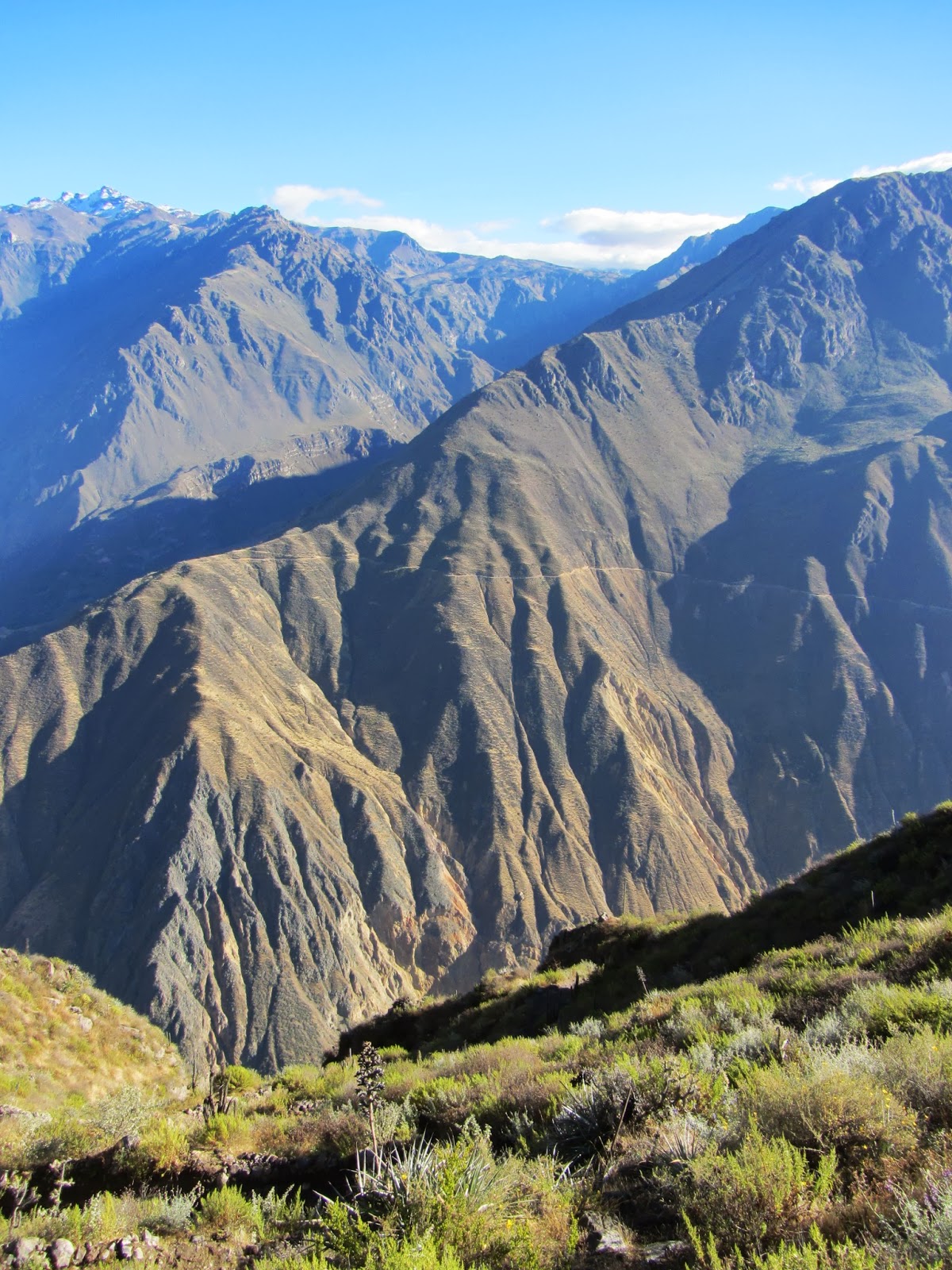
After an outrageously good nights sleep, we were up for a 0730 breakfast before setting off through the various villages which dotted the trail to our next stop, Sangalle, or more affectionately known as 'The Oasis'. Thankfully the weather had cleared and we could finally see the beautiful landscape and area we found ourselves in. The path was pretty steep and narrow for the first half hour or so and after a steep section we stopped to catch our breath and stock up on snacks and water as they're much more expensive in Sangalle.

The locals around here rely on pack horses and donkeys to traverse the same path we took yesterday to get supplies, but there is also a new road now that leads to the villages, only this takes six hours to get to Cabanaconde and has been built by a mining company as gold has been found in the local area. As with Bolivia, mining is a most lucrative and important business to cooparation's and locals keen enough to get involved.

The path continued to follow the curvature of the canyon until we reached an area known as Jarejna, this looked just like a crater but somehow on the side of the canyon wall. Incas used to use it for agriculture and the terraces formed all that time ago are still apparent but now it is used mainly as the site of a special annual World Cup where all the local villages register teams to play. This is a massive event each year, with everyone in the Tapay district turning up in their finest and a chance for the men in the area to impress the local ladies with their talents.

Once past this section, the path becomes much steeper, starts to zig zag and offers great views into the canyon and the days destination, Sangalle. From above, it really does look like an oasis. There is a natural spring close by and this has helped to cultivate a tropical feel deep in the canyon where there are palm trees everywhere, water from the spring filling swimming pools and individual huts for punters trekking through the canyon. An unexpected piece of paradise deep in the canyon.

Once down the path, everyone is able to take a plunge in the pools, relax and enjoy the rest of the day lounging in this unlikely place. Another reason I would recommend the three day trek is that if you do the two day trek you arrive here late in the evening as it is getting dark so you can't really take advantage of the pool and relax. Instead, you are pretty tired from 20km walking (in yesterday's case in the rain all day) and then you have to get up at the crack of dawn to climb out of the canyon.


Come 5am, everyone is packed and ready to head out of the canyon, no breakfast here, have to rely on having had sufficient food from the dinner and plenty of sleep, the latter not really being a problem, my appetite however causing me to be hungry all the time on this trip.

The walk itself isn't the most taxing, it's just long more than anything else. The path is again a zig zag pattern as opposed to a straight up incline, like day two of the Inca trail for example, so a slow and steady pace will see you gain the 1200m you originally descended in two and a half hours. At the top, Cabanaconde is in sight and a short walk through the local fields will take you to the village and breakfast.

Once eaten, the group is lead back to the minibus and taken to the look out point at Hangahuilca where you can get an even better perspective of how big the canyon is and how well the locals use the land, with terraces dotted across the canyon side everywhere. From here we were taken to Maca, an unassuming local village where they sell the usual Peruvian fare and then on to some underwhelming hot springs at Chacapi. By now I was somewhat hungry so our next destination at Chivay for an all you can eat buffet was more than appreciated, and as usual, I was completely unable to show any form of restraint.

From here the tour pretty much winds down and the driver takes you back towards Arequipa via an Andes mountain range viewpoint which includes views of  the following volcanoes: Mismi, Hualca Hualca, Sabancaya, Ampato, Chachani, Misti, Ubinas and Chuchura. After this we drove along one of the main highways back to Arequipa which happens to go through a national park full of alpacas and llamas. By the early evening we arrived back at the Plaza de Armas in time for a quick shower and an onward bus to Lima.


Friday 17 May 2013

Inca Trail to Macchu Picchu: Part 2

Day three is around 12km and is regarded as the longest day as it mainly consists of up and down sections which skirt around Salkantay mountain to Intipata, and perhaps seen as the cultural day on the trail as three ruins lie along it. It began with yet another early wake up call at around 5:30am with breakfast soon after and by 7am we were on the road again. The trail was an immediate wake up call as it was uphill for around 45 minutes to see the first of the three Inca ruins, Runcuracay, or in English, 'The Circular Building', or so our guide said.

Discovered by Hiram Bingham in 1915, Runcuracay sits at an altitude of around 3750m overlooking the valley and was possibly used as a storehouse for food which was then distributed to locals amongst the hills, a watch tower as it has such great vantage points over the valley and all the way up to Dead Woman's pass or a shelter for messengers to rest after running all day. The likelihood is that this place was in fact used for all of the above.

From here the path continues to ascend, passing a lake on the way, until the pass at 3950m is reached. Looking back there are incredible views back towards camp from the previous night but the views on the horizon are more impressive with the mountains providing a gorgeous backdrop and the second of the Inca ruins, Sayacmarca, hugging the rock wall of the mountain where the path lies.

After taking pictures, the group slowly wound it's way down to Sayacmarca, known as 'The Inaccessible Place' and for good reason as the 98 steep steps that lead up to it are real energy sappers. The ruin is said to have been a refuge area and was only occupied seasonally, experts think the people who lived here survived on food rations from Runcuracay and by a 3.5km aquaduct they crafted which provided them with water from the surrounding mountains.

From here the path winds down into the valley and passes another ruin by the name of Conchamarka before coming to the resting point of Chaquiconcha. The path then undulates for a while before steadily climbing with mountains dominating the views on the left side, after a while the 6200m mountain Salkantay is in view and with perfect weather the top of the mountain is visible. By and large this peak is obscured by cloud cover and mist but we were blessed with good weather so we had perfect views all around. Come the end of this section, the walk becomes a little steeper before cresting the ridge and coming across our lunch stop at Phuyupatamarka; the name of the campsite and the nearby ruin.

After lunch, we checked out this ruin. In English the name translates to 'City in the Clouds' and again, this facility is believed to have been used seasonally and mainly as an observatory. From where this ruin is situated, on a clear night so much of the sky would be visible it's not hard to see why this area was picked.

Descending some 400m, the path thereafter is steep with uneven stones and steps carved out of the ground and steep drop offs on the right side of the trail with the path itself being less than a metre wide in some places. After an hour, the path cuts through a tunnel crafted out of the rock face and becomes much flatter although still slowly descending into the valley.

From Phuyupatamarka, it is possible to make out the terraces of Intipata and after another hour or so these terraces are reached. They were mainly used for growing corn and potatoes and most of the produce here will have made it's way to Macchu Picchu which is only around 5km away. The campsite for the night is just around the corner but before bedding in for the night we checked out another ruin called Winyawayna. This one had an even more impressive set of agricultural terraces than Intipata and is a concave shape as opposed to Initpata's convex one. There are two sets of buildings separated by yet another aquaduct/fountain system which is amazingly still functioning, these Incans built things to last.

Runcuracay


Path leading down to Sayacmarca
Sayacmarca
View on Sayacmarca
Sayacmarca
Salkantay


Phuyupatamarka from afar
Steps leading up Phuyupatamarka


Intipata


After three days of struggling up and down mountains and through valleys, the short walk of 5km to Macchu Picchu from Winyawayna was a welcome reprieve, although to get to Macchu Picchu at a decent hour we were up and packed by 4am.

The actual checkpoint doesn't open until 5:30am however so it's best to get packed and queue up, the better placed you are in the queue, the sooner you get to Intipunku, or the Sun Gate. Passing out other groups isn't so much against the rules, merely frowned upon as the path, which skirts around the actual mountain named Macchu Picchu, is very thin in places with yet more drop offs in what is now dense jungle as the dizzy heights of 4200m have been left behind for the more hospitable sub 3000m range.

After about 3km, the steep steps that lead to Intipunku  are in reach and by far the steepest of the trek. Thankfully they aren't too long but you are left gasping for breath when you reach the top, however from here it is a matter of minutes before you reach the Sun Gate itself and finally see Macchu Picchu for the first time.

At this stage, you finally get to see all the other people who have been doing the Inca trail. Only 500 people a day are allowed to do the trail and over the last three days, you barely see anyone else. However, at this bottleneck, the place is teeming with other people, straining to get their breath back and sitting down whilst taking in the view. Macchu Picchu is still a couple kilometres away but just seeing it gives everyone that boost that is needed to complete the rest of the jorney to the entrance of this lost city. Once there, there is a service available to finally get rid of that backpack you've been carrying the past three days and walk around this beautiful 'Lost City of the Incas' .

Macchu Picchu from afar


Terraces at the Sun Gate


Macchu Picchu


Four days and 43km from where we started finally brought the group to Macchu Picchu. Before undertaking this trek, I had heard many people describing the trek itself as impressive and as rewarding as seeing Macchu Picchu itself and after completing it I can understand exactly what they meant. The sights seen and friends made along the way were astounding and reaching Macchu Picchu was the culmination of a great trek which will stay with me for years to come. Highlight of the trip so far perhaps.