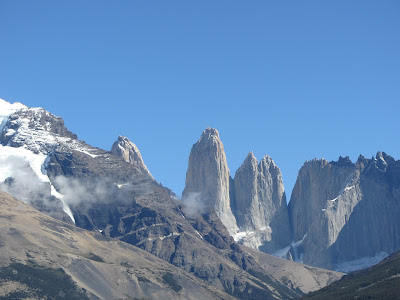
Some 140km away (going on the old road) from Puerto Natales is the Torres del Paine (Towers of Pain) National Park, perhaps Chile's most famous and home to the fabled 'W' trek. Described as one of the best low altitude treks in the world, there are waterfalls, lakes, streams, glaciers, forest paths, boulder scrambling, refugios and campsites abound and of course the main draw, the actual Towers of Pain themselves.
There are a couple ways of going about doing the trek. First you have to decide whether or not you want to do just the 'W' trek which takes four or five days depending on quick you do it, or the circuit which takes around nine. Once you know how long you'll be, the next obstacle is food and lodgings. The refugios are plentiful enough but the food is expensive and the lodgings even more so, one of them charged $41 a night for a bed, no sheets. No thanks. With that in mind, you need to carry a tent, sleeping, sleeping mat (recommended) and your food and cooker, quite a handful but manageable when split between two or more people depending on the size of your party.

Above is a map of the W trek and if you wish to do the full circuit, just follow the dotted black line after the coloured ones. For the W trek you can go from either east to west or west to east, many people choose the former but that only really makes sense if the weather is clear on the day you arrive and you think you will get a good view of the towers. With it been overcast upon arrival, taking the catamaran across Lake Pehoe to Refugio Paine Grande and going west to east made more sense. We decided to take it easy so opted for the five day W trek.
Day 1: Refugio Paine Grande to Refugio Grey (11km)
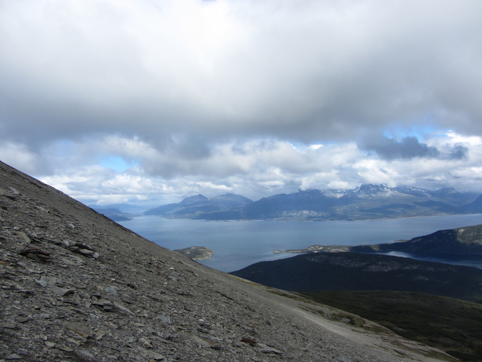
From Refugio Paine Grande it is easy enough to find the path (we initially took the wrong one mind) and then head up through the valley towards Refugio Grey, the campsite for the night. Along the way you walk past Laguna Los Patos but you can't see Lake Grey until you come to the viewpoint for it. As you approach it, the winds pick up and come the time you arrive at the viewpoint, it's so blustery you'd want to take your bag off for photos for fear of getting swept over the edge.
The land is a little more rocky around here as the path winds down to the campsite, the terrain also shows the scars of one of the fires started by a tourist a few years ago, so many trees scorched trying to heal but it will be a long time before that happens. There are a couple streams to cross, a bridge that has been botched together after it fell apart and a final thirty minutes or so downhill over a rocky path until you finally reach the campsite. With the tent up in the wind, pasta for dinner and a luke warm shower later, there's not a whole lot more to do other than crack open the wine (brought the essentials with us) and relax before sleep takes over.


Day 2: Refugio Grey to Campamento Italiano (18.5km)
With the the trek been in the shape of a W, there are three dead ends so you need to head back along the path you came, navigating the rocks but this time going up which is a bit more tiring, it certainly wakes you up though. The way back down is a bit quicker and at Refugio Paine Grande you can stop and cook up some lunch.
Fed and rested, the path now extends eastwards parallel to Lake Skottsberg with great views ahead until the path became a little skinnier and overgrown with hedgerows so you can't see too much in the way of anything beyond the path ahead. From the Refugio to Campamento Italiano, it's a 7.5km hike and takes two to three hours until you reach the bridge that takes you over Rio del Frances and to the camp. This is a free campsite amongst the trees and a much busier one as you start to recognise faces and from here on in spend the evenings chilling out with the same people.


Day 3: Campamento Italiano to Refugio Los Cuernos via Valle del Frances viewpoint (20.5km)
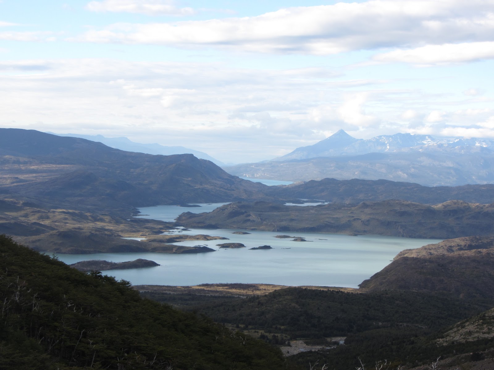
Easier start to the walking today as you can leave your tent and belongings behind and walk up to the viewpoint with just a day pack with water and snacks. The path follows Rio (river) del Frances all the way up the valley; initially it is a very rocky haphazard route which then gives way to cobbled ground and woodland. Halfway through the walk there is a decent viewpoint of the mountains up ahead but to get the best views you need to get to the main viewpoint in the valley. Here, there are panoramic views of Cordillera Paine dead ahead, mountains Cabeza del Indio, Escudo and Fortaleza on the right with Aleta de Tiburon dominating the west.
Once you make your way back to camp, it is an easy day in that you only have to carry the packs for 5.5km more to Campamento Los Cuernos. By now, half the food is gone and your body is getting used to the punishment. The views on this stretch are beautiful with Lake Nordernskjold always in sight until halfway to the campsite, from here the hedges become somewhat thicker, barely wide enough to walk through without ripping something, and you pop up in the camp itself when you hit the shoreline again.


Day 4: Los Cuernos to Campamento Torres (20km)
Definitely the toughest day of the trek as most of it is uphill, however it makes for a somewhat easier following day. The tent was soaking even though it didn't rain and in the shadow of the mountains it was a cold morning. Once you get going and the sun reaches its zenith however, it is hard work as it was steep going and then the path yo-yoed up and down whilst still gaining elevation.
Eventually you get to the shortcut which leads up to Refugio Chileano, the camp before Campamento Torres. After a boggy start, it levelled out and with the sun shining it was a lovely section, so much so we chilled out for a lunch break and to dry the tent out. Only when we got going again did we realise we were right at the bottom of the tough bit, from here on up to the camp it was steady uphill going.
The views through the valley were amazing, but once you get to Chileano you still have 5km to go until you reach Campamento Torres. This was mostly under cover of trees so in the shade but constantly uphill with no respite from the gradient. A big campsite greets you at the top and by now you know a fair few people who, if you're not walking with them, you meet at the end of each day to have a chat and a drink with.


Day 5: Campamento Torres to Hotel Las Torres via Base de las Torres (10km)
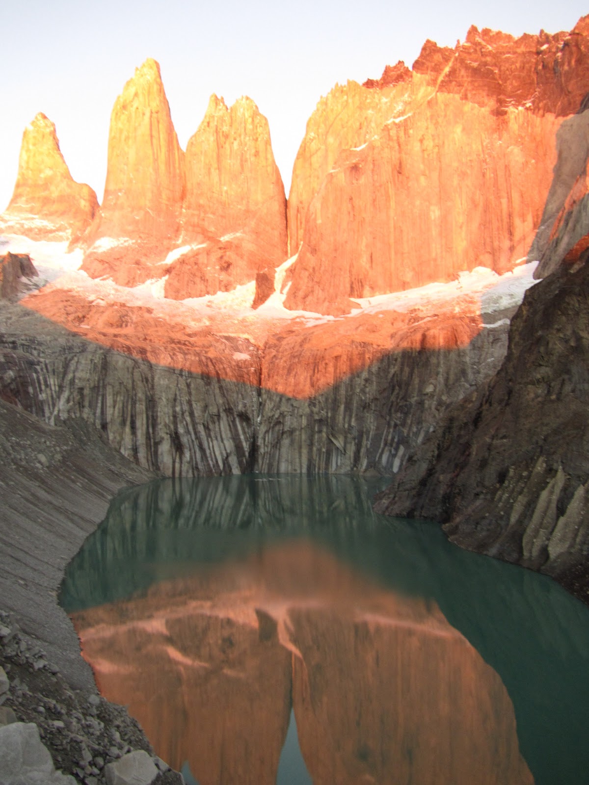
Early start in the dark to try and make it for sunrise, only need to bring water. Only an hour up but in the dark the path is difficult to find at times and come the top of the track, nigh on impossible and it becomes a boulder scramble. Only in the light of day could I see the path that leads right up to the lake in front of the towers, having not seen it I literally climbed up to the highest point possible to try and get the sunrise and to the towers. Unfortunately the sunrise was somewhat obscured by the surrounding mountains but it really is spectacular as the light hits the towers and works its way down their surface so they reflect in the lake below.
Coming down is obviously much easier and in the light you can pack up your gear and start the shorter walk down to the finish at Hotel Las Torres. Aside from a couple dips the way is pretty much all downhill and this is the route you would have to take up if you didn't take the shortcut. The shortcut was much easier in comparison as this way going up would have been brutal, those who did it said as much too.
Come the end of the route there is a little kiosko selling hot dogs and beers, a perfect way to end the day and the trek before getting picked up to be taken back to Puerto Natales for a hot dinner and shower.


As treks go, this was pretty tough but very rewarding as each day brought fresh new scenery with the views only getting better by going west to east, in my opinion. The weather was amazing and aside from a sprinkle of rain the first couple days, the sunshine was glorious and the mountains and the lakes looked immense. As the trek goes on, the backpack gets that little bit lighter each day too, so come the end of the trek the walk down is, dare I say it, easy. Also, by going west to east you avoid having to lug all your gear up to Campamento Torres on the first day which would be a fair old effort. All in all, an incredible hiking experience I'd recommend to anyone.
There are a couple ways of going about doing the trek. First you have to decide whether or not you want to do just the 'W' trek which takes four or five days depending on quick you do it, or the circuit which takes around nine. Once you know how long you'll be, the next obstacle is food and lodgings. The refugios are plentiful enough but the food is expensive and the lodgings even more so, one of them charged $41 a night for a bed, no sheets. No thanks. With that in mind, you need to carry a tent, sleeping, sleeping mat (recommended) and your food and cooker, quite a handful but manageable when split between two or more people depending on the size of your party.
Above is a map of the W trek and if you wish to do the full circuit, just follow the dotted black line after the coloured ones. For the W trek you can go from either east to west or west to east, many people choose the former but that only really makes sense if the weather is clear on the day you arrive and you think you will get a good view of the towers. With it been overcast upon arrival, taking the catamaran across Lake Pehoe to Refugio Paine Grande and going west to east made more sense. We decided to take it easy so opted for the five day W trek.
Day 1: Refugio Paine Grande to Refugio Grey (11km)
From Refugio Paine Grande it is easy enough to find the path (we initially took the wrong one mind) and then head up through the valley towards Refugio Grey, the campsite for the night. Along the way you walk past Laguna Los Patos but you can't see Lake Grey until you come to the viewpoint for it. As you approach it, the winds pick up and come the time you arrive at the viewpoint, it's so blustery you'd want to take your bag off for photos for fear of getting swept over the edge.
The land is a little more rocky around here as the path winds down to the campsite, the terrain also shows the scars of one of the fires started by a tourist a few years ago, so many trees scorched trying to heal but it will be a long time before that happens. There are a couple streams to cross, a bridge that has been botched together after it fell apart and a final thirty minutes or so downhill over a rocky path until you finally reach the campsite. With the tent up in the wind, pasta for dinner and a luke warm shower later, there's not a whole lot more to do other than crack open the wine (brought the essentials with us) and relax before sleep takes over.


Day 2: Refugio Grey to Campamento Italiano (18.5km)
With the the trek been in the shape of a W, there are three dead ends so you need to head back along the path you came, navigating the rocks but this time going up which is a bit more tiring, it certainly wakes you up though. The way back down is a bit quicker and at Refugio Paine Grande you can stop and cook up some lunch.
Fed and rested, the path now extends eastwards parallel to Lake Skottsberg with great views ahead until the path became a little skinnier and overgrown with hedgerows so you can't see too much in the way of anything beyond the path ahead. From the Refugio to Campamento Italiano, it's a 7.5km hike and takes two to three hours until you reach the bridge that takes you over Rio del Frances and to the camp. This is a free campsite amongst the trees and a much busier one as you start to recognise faces and from here on in spend the evenings chilling out with the same people.


Day 3: Campamento Italiano to Refugio Los Cuernos via Valle del Frances viewpoint (20.5km)
Easier start to the walking today as you can leave your tent and belongings behind and walk up to the viewpoint with just a day pack with water and snacks. The path follows Rio (river) del Frances all the way up the valley; initially it is a very rocky haphazard route which then gives way to cobbled ground and woodland. Halfway through the walk there is a decent viewpoint of the mountains up ahead but to get the best views you need to get to the main viewpoint in the valley. Here, there are panoramic views of Cordillera Paine dead ahead, mountains Cabeza del Indio, Escudo and Fortaleza on the right with Aleta de Tiburon dominating the west.
Once you make your way back to camp, it is an easy day in that you only have to carry the packs for 5.5km more to Campamento Los Cuernos. By now, half the food is gone and your body is getting used to the punishment. The views on this stretch are beautiful with Lake Nordernskjold always in sight until halfway to the campsite, from here the hedges become somewhat thicker, barely wide enough to walk through without ripping something, and you pop up in the camp itself when you hit the shoreline again.


Day 4: Los Cuernos to Campamento Torres (20km)
Definitely the toughest day of the trek as most of it is uphill, however it makes for a somewhat easier following day. The tent was soaking even though it didn't rain and in the shadow of the mountains it was a cold morning. Once you get going and the sun reaches its zenith however, it is hard work as it was steep going and then the path yo-yoed up and down whilst still gaining elevation.
Eventually you get to the shortcut which leads up to Refugio Chileano, the camp before Campamento Torres. After a boggy start, it levelled out and with the sun shining it was a lovely section, so much so we chilled out for a lunch break and to dry the tent out. Only when we got going again did we realise we were right at the bottom of the tough bit, from here on up to the camp it was steady uphill going.
The views through the valley were amazing, but once you get to Chileano you still have 5km to go until you reach Campamento Torres. This was mostly under cover of trees so in the shade but constantly uphill with no respite from the gradient. A big campsite greets you at the top and by now you know a fair few people who, if you're not walking with them, you meet at the end of each day to have a chat and a drink with.
 |


Day 5: Campamento Torres to Hotel Las Torres via Base de las Torres (10km)
Early start in the dark to try and make it for sunrise, only need to bring water. Only an hour up but in the dark the path is difficult to find at times and come the top of the track, nigh on impossible and it becomes a boulder scramble. Only in the light of day could I see the path that leads right up to the lake in front of the towers, having not seen it I literally climbed up to the highest point possible to try and get the sunrise and to the towers. Unfortunately the sunrise was somewhat obscured by the surrounding mountains but it really is spectacular as the light hits the towers and works its way down their surface so they reflect in the lake below.
Coming down is obviously much easier and in the light you can pack up your gear and start the shorter walk down to the finish at Hotel Las Torres. Aside from a couple dips the way is pretty much all downhill and this is the route you would have to take up if you didn't take the shortcut. The shortcut was much easier in comparison as this way going up would have been brutal, those who did it said as much too.
Come the end of the route there is a little kiosko selling hot dogs and beers, a perfect way to end the day and the trek before getting picked up to be taken back to Puerto Natales for a hot dinner and shower.


As treks go, this was pretty tough but very rewarding as each day brought fresh new scenery with the views only getting better by going west to east, in my opinion. The weather was amazing and aside from a sprinkle of rain the first couple days, the sunshine was glorious and the mountains and the lakes looked immense. As the trek goes on, the backpack gets that little bit lighter each day too, so come the end of the trek the walk down is, dare I say it, easy. Also, by going west to east you avoid having to lug all your gear up to Campamento Torres on the first day which would be a fair old effort. All in all, an incredible hiking experience I'd recommend to anyone.