Even with an everlasting budget and no time limit, I would have a hard old time trying to see and do everything possible in Patagonia, it's so vast, places are so remote and you could quite happily stay in one place for an extended period just because you like the feel of it. However, with a budget and time constraints come decisions so here are just a few of the places you can go and things you can see in this beautiful part of the world.
This glacier is in the southern Patagonian ice field, home to 47 glaciers with this one not even close to being the biggest. Coming in at 30km long, 5km wide and an average of 60m high, it is still a massive natural wonder that is now in equilibrium, rather than receding like most of the other glaciers in this ice field and the rest of the world.
As always, there are many ways to go about seeing this behemoth. You could rent a car, go on a local bus or go on a tour, however if you want to get up close and personal rather than just view it from the vantage points then a tour is the only way to go. Through the company Hielo y Aventura, you have two possibilities: Mini Trekking which gives about 1 hour on the ice and The Big Ice which has around 3 hours of time on the ice for just a bit more, easy enough decision to make then.
As with all tours, you get picked up at your hotel and from there on you are pretty much on the time schedule allotted and just have to hope you don't get on a group with people who dilly-dally and waste time, the more this happens the less time on the ice.
The glacier is around 80km from the town of El Calafate along a road which is basically a straight shot to Los Glaciares National Park, no prizes for guessing the translation. After paying the inaugural national park entrance fee, the bus goes to the viewing platforms where you can walk along the walkways and see the glacier's south and north face, from a distance of course. The glacier is constantly cracking, sounding like thunder most of the time as it creaks, with luck you can see a part of the glacier fall off and crash into the water below.
Once the staring from afar is over, it is time to get on a boat and after disembarking, follow the guides to the glacier's edge where you get a brief of what will happen and get kitted out with crampons for the walk. The guides lead and follow the group so as to avoid any undue accidents and map out a path through the ice.
There are streams of melted water throughout the glacier, with their routes constantly changing as the ice moves and melts. Around halfway through the guides bring the group to a lagoon of sorts which is a brilliant blue colour and here photo shots abound as well as lunch. After this, it is time to head back to the start but a different way, there's no way you could follow the path taken inward. Once back at the start, the tour group heads back to the boat and then back to town. A fun day out but if you're on a budget maybe just go for the local bus to the viewpoint.


Some 215km from El Calafate lies El Chalten, Argentina's trekking capital and home to the Fitz Roy mountain range, with Cerro (Mount) Fitz Roy itself being the premier attraction. The range is still technically in the Glaciers National Park and is also incredibly popular for rock climbing as well if you are into that. Even though there are plenty of trails in the area, rather than lugging provisions, a tent and sleeping bag about to the campsites, it is just as easy to base yourself in the township and do day hikes.
In the area there are two main trails to follow if you are doing day trips. One winds its way to the view point for Mount Fitz Roy itself; to get on this trail all you have to do is follow the main road north out of town and it basically turns into the path itself. The first hour or so is pretty steep going through the woods and after a while the path splits off in two ways: one for Camp Laguna Capri and the other for the first viewpoint of Fitz Roy. In the brilliant sunshine it really is spectacular.
From here the going is pretty standard and there's not much to see as views are obscured by the trees, however once you cross Rio Blanco things get a little more difficult; it's basically an uphill assault to get to the top which takes about an hour. No need to rush here, it really is knackering. Once at the top, there is an amazing view of Mount Fitz Roy and Laguna de los Tres and it is possible to get right down to the water. After relaxing at the top, the only thing left to do is head back down the way you came unless you take a detour via Lago Madre and Lago Hija, something that won't really add anything to your walking.
Another trail on offer leads to Lago Torres, a five hour round trip if you are walking at a decent pace. Unfortunately, the trail itself offers nothing as after the initial spurt up hill where the land is open and you are walking through a valley, it is mainly sheltered by trees and dense foliage with narrow paths offering limited views there after. Once at the end of the path, it opens up again and after rounding a few corners where there is so much erosion there are only stones and rock left, Lago Torres is in sight with Glacier Grande in the background. The weather wasn't as good for this trek as it had been for the previous one but it was still a cracking view, just wish there was a little more on offer on the way to it.


Some 20+ hours bus ride away from El Chalten is Bariloche, the biggest city in the Argentine Lake District. The main city hugs the edge of Lago Nahuel Huapi but it is such a tourist trap it is better to stay outside of the city along the main road which runs parallel to the lake. Considering the area is a mecca for skiing in the winter and hiking in the summer, it is busy all year round so beyond chocolate shops, restaurants and St. Bernards with bells on which you have photos with (city tradition apparently), there isn't much to do there.
Buses run along Avenida Bustillo which links the city with all the attractions in the area. When getting on you have to tell the driver which stop you want by specifying the distance marker you want to get off at rather than the destination so it's good to know your Spanish numbers here.
When the weather is great, it is definitely a good idea to head towards Cerro Campanario for views of the area. To get to the top, there is a heavily priced gondala or a steep rocky path which takes about 30 minutes to traverse, again very tiring but the panoramic views on offer are nothing short of spectacular. National Geographic stated that this was one of the top 10 views in the world and I can see why, on a clear day it really is nothing short of magic.
There are other mountains in the area which are possible to climb: Cerro Catedral, Cerro Goye, Cerro Bella Vista and so on, but these require more time and are usually undertaken as four to five day treks so all of them can be fit in in one go.
At the end of Avenida Bustillo, there are a couple of places where you can rent bikes to cycle along the Circuito Chico, a 25km stretch of road that loops around the Llao Llao area of the park taking in views of Lago Moreno which is divided into an east and west side, and various tracks which lead off to view points.
The area also boasts a Swiss colony, and on Wednesdays and Sundays it is open to the public, who come in droves to sample some Swiss comfort food and other delicacies. I have to say, the cake was a real treat compared to most desserts on offer here. Just make sure you check the bus timetable when coming out here as it is haphazard to say the least and you could end up waiting two hours for a bus, not the highlight of the day.


Of course there are plenty more national parks, activities and places to visit in Patagonia and the Lake District but you wouldn't scratch the surface given months of time here. The best plan of attack is to know which places you definitely want to visit beforehand and plan accordingly as the distance between some places is pretty far. For example, Bariloche to Mendoza is another 20+ hour bus ride away, where I will be swapping the fresh air and calm of Patagonia for the hustle and bustle of a city and region famous for its wine, I think I'll enjoy this change of pace.
Perito Moreno Glacier
This glacier is in the southern Patagonian ice field, home to 47 glaciers with this one not even close to being the biggest. Coming in at 30km long, 5km wide and an average of 60m high, it is still a massive natural wonder that is now in equilibrium, rather than receding like most of the other glaciers in this ice field and the rest of the world.
As always, there are many ways to go about seeing this behemoth. You could rent a car, go on a local bus or go on a tour, however if you want to get up close and personal rather than just view it from the vantage points then a tour is the only way to go. Through the company Hielo y Aventura, you have two possibilities: Mini Trekking which gives about 1 hour on the ice and The Big Ice which has around 3 hours of time on the ice for just a bit more, easy enough decision to make then.
As with all tours, you get picked up at your hotel and from there on you are pretty much on the time schedule allotted and just have to hope you don't get on a group with people who dilly-dally and waste time, the more this happens the less time on the ice.
The glacier is around 80km from the town of El Calafate along a road which is basically a straight shot to Los Glaciares National Park, no prizes for guessing the translation. After paying the inaugural national park entrance fee, the bus goes to the viewing platforms where you can walk along the walkways and see the glacier's south and north face, from a distance of course. The glacier is constantly cracking, sounding like thunder most of the time as it creaks, with luck you can see a part of the glacier fall off and crash into the water below.
Once the staring from afar is over, it is time to get on a boat and after disembarking, follow the guides to the glacier's edge where you get a brief of what will happen and get kitted out with crampons for the walk. The guides lead and follow the group so as to avoid any undue accidents and map out a path through the ice.
There are streams of melted water throughout the glacier, with their routes constantly changing as the ice moves and melts. Around halfway through the guides bring the group to a lagoon of sorts which is a brilliant blue colour and here photo shots abound as well as lunch. After this, it is time to head back to the start but a different way, there's no way you could follow the path taken inward. Once back at the start, the tour group heads back to the boat and then back to town. A fun day out but if you're on a budget maybe just go for the local bus to the viewpoint.
Mount Fitz Roy
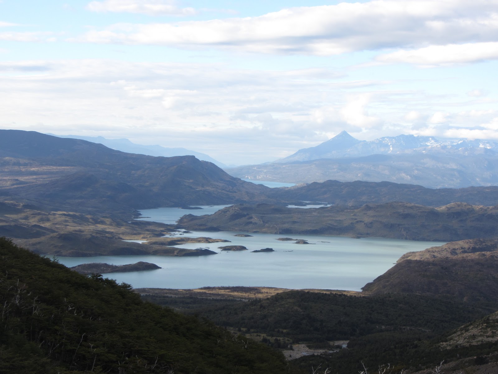
Some 215km from El Calafate lies El Chalten, Argentina's trekking capital and home to the Fitz Roy mountain range, with Cerro (Mount) Fitz Roy itself being the premier attraction. The range is still technically in the Glaciers National Park and is also incredibly popular for rock climbing as well if you are into that. Even though there are plenty of trails in the area, rather than lugging provisions, a tent and sleeping bag about to the campsites, it is just as easy to base yourself in the township and do day hikes.
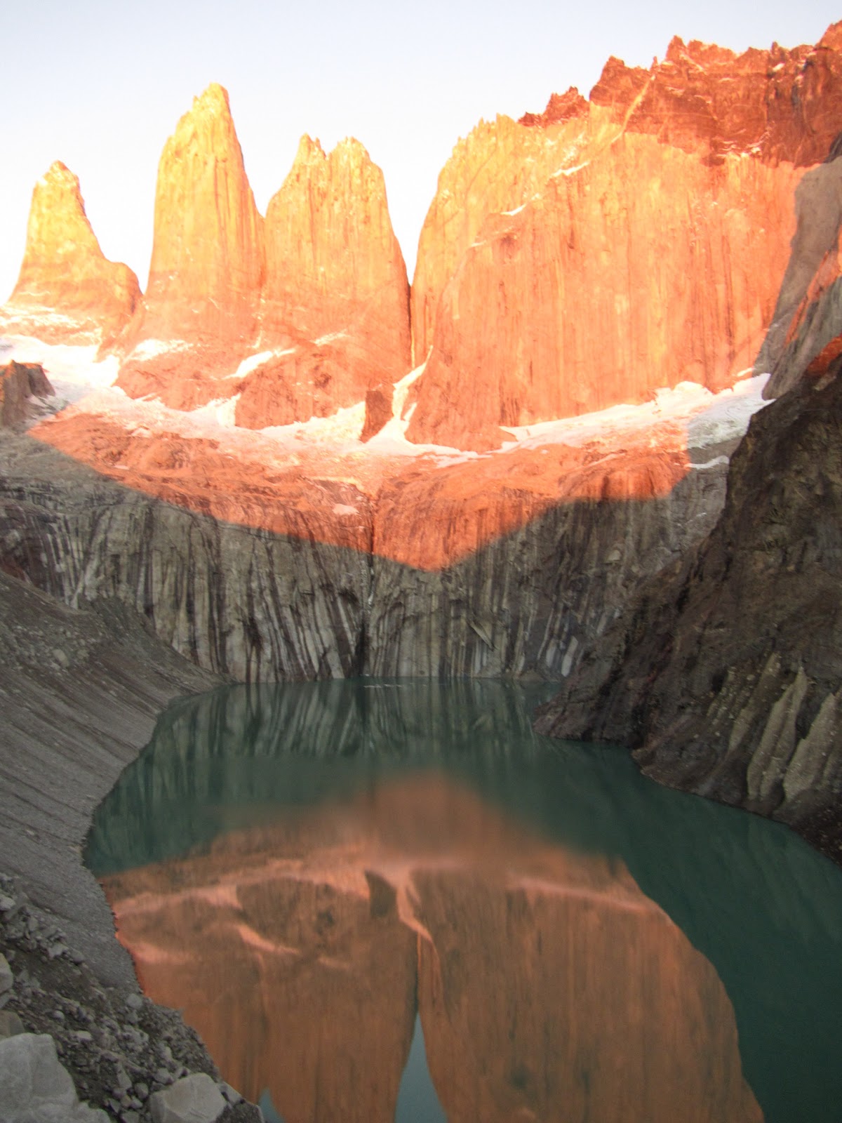
In the area there are two main trails to follow if you are doing day trips. One winds its way to the view point for Mount Fitz Roy itself; to get on this trail all you have to do is follow the main road north out of town and it basically turns into the path itself. The first hour or so is pretty steep going through the woods and after a while the path splits off in two ways: one for Camp Laguna Capri and the other for the first viewpoint of Fitz Roy. In the brilliant sunshine it really is spectacular.
From here the going is pretty standard and there's not much to see as views are obscured by the trees, however once you cross Rio Blanco things get a little more difficult; it's basically an uphill assault to get to the top which takes about an hour. No need to rush here, it really is knackering. Once at the top, there is an amazing view of Mount Fitz Roy and Laguna de los Tres and it is possible to get right down to the water. After relaxing at the top, the only thing left to do is head back down the way you came unless you take a detour via Lago Madre and Lago Hija, something that won't really add anything to your walking.
Another trail on offer leads to Lago Torres, a five hour round trip if you are walking at a decent pace. Unfortunately, the trail itself offers nothing as after the initial spurt up hill where the land is open and you are walking through a valley, it is mainly sheltered by trees and dense foliage with narrow paths offering limited views there after. Once at the end of the path, it opens up again and after rounding a few corners where there is so much erosion there are only stones and rock left, Lago Torres is in sight with Glacier Grande in the background. The weather wasn't as good for this trek as it had been for the previous one but it was still a cracking view, just wish there was a little more on offer on the way to it.
 |
| First view of Mount Fitz Roy |
 |
 |
| Fitz Roy with Laguna de los Tres |
San Carlos de Bariloche
Some 20+ hours bus ride away from El Chalten is Bariloche, the biggest city in the Argentine Lake District. The main city hugs the edge of Lago Nahuel Huapi but it is such a tourist trap it is better to stay outside of the city along the main road which runs parallel to the lake. Considering the area is a mecca for skiing in the winter and hiking in the summer, it is busy all year round so beyond chocolate shops, restaurants and St. Bernards with bells on which you have photos with (city tradition apparently), there isn't much to do there.
Buses run along Avenida Bustillo which links the city with all the attractions in the area. When getting on you have to tell the driver which stop you want by specifying the distance marker you want to get off at rather than the destination so it's good to know your Spanish numbers here.
When the weather is great, it is definitely a good idea to head towards Cerro Campanario for views of the area. To get to the top, there is a heavily priced gondala or a steep rocky path which takes about 30 minutes to traverse, again very tiring but the panoramic views on offer are nothing short of spectacular. National Geographic stated that this was one of the top 10 views in the world and I can see why, on a clear day it really is nothing short of magic.
There are other mountains in the area which are possible to climb: Cerro Catedral, Cerro Goye, Cerro Bella Vista and so on, but these require more time and are usually undertaken as four to five day treks so all of them can be fit in in one go.
At the end of Avenida Bustillo, there are a couple of places where you can rent bikes to cycle along the Circuito Chico, a 25km stretch of road that loops around the Llao Llao area of the park taking in views of Lago Moreno which is divided into an east and west side, and various tracks which lead off to view points.
The area also boasts a Swiss colony, and on Wednesdays and Sundays it is open to the public, who come in droves to sample some Swiss comfort food and other delicacies. I have to say, the cake was a real treat compared to most desserts on offer here. Just make sure you check the bus timetable when coming out here as it is haphazard to say the least and you could end up waiting two hours for a bus, not the highlight of the day.
Of course there are plenty more national parks, activities and places to visit in Patagonia and the Lake District but you wouldn't scratch the surface given months of time here. The best plan of attack is to know which places you definitely want to visit beforehand and plan accordingly as the distance between some places is pretty far. For example, Bariloche to Mendoza is another 20+ hour bus ride away, where I will be swapping the fresh air and calm of Patagonia for the hustle and bustle of a city and region famous for its wine, I think I'll enjoy this change of pace.